Custom software, interactive maps and geospatial data solutions
We help municipalities, consulting firms, NGOs and international organizations capture, visualize and manage geospatial information efficiently.
Our services
Three specialized service lines that combine to fit each project's needs.


Urban platform: participatory georeferencing
A web and mobile system to collect, organize and visualize information directly from the field. It integrates a dissemination map, data management tools and a mobile app that uses the phone's GPS to capture information on the ground.
It significantly cuts the time and cost of field data collection by eliminating manual consolidation. Information is generated, validated and published in real time.

Solving real problems, one project at a time
We have worked with organizations across Chile, Spain and Latin America. We work directly with the client — no account managers, no subcontractors — and continuously adapt to emerging technologies.
Talk about your projectMunicipalities & local governments
Communal development plans, territorial diagnostics, citizen participation and project monitoring.
International organizations
IDB, European NGOs and multilateral development and urban planning projects.
Universities & institutions
Collection maps, research platforms and academic management systems.
NGOs & social organizations
Community service mapping, program management and participation tools.
Consulting firms
Custom software, management platforms and spatial data analysis tools.

Software built by people, for people
We are a small, specialized team. We've learned that the best solutions come from understanding the real problem before writing the first line of code.
We work directly with our clients — no management layers, no subcontractors — and continuously adapt to emerging technologies to deliver robust, impact-oriented solutions.
Free tools
Resources we've built and made available to the community at no cost.
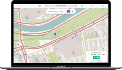
Get coordinates with one click
Click anywhere on the map and get latitude and longitude ready to copy. Useful for reports, spreadsheets, GIS systems or any app that needs precise geographic data.
Use tool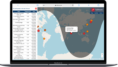
Real-time seismic activity
Interactive map showing all earthquakes recorded worldwide in the last 24 hours. Magnitude, depth and exact location. Data from the USGS, updated continuously.
View seismic mapReady to transform your project?
Tell us your challenge. You'll hear back within 24 hours.
Contact us nowContact us
Have a project in mind? Tell us about it and we'll get back to you quickly.
Location
Business hours
Monday to Friday
9:00 – 18:00 hrs (Chile)
We respond within 24 business hours.